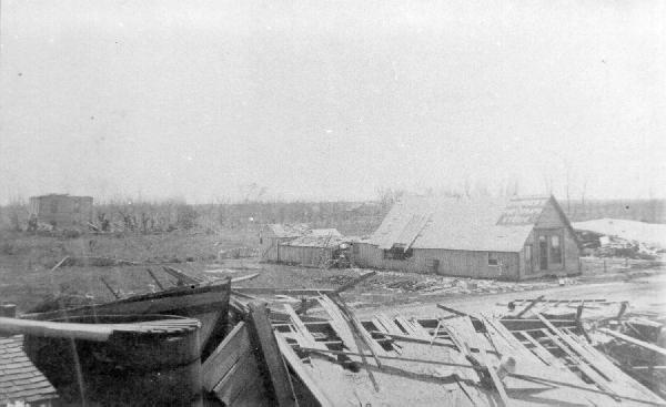


Hurricane Carla 9/11/1961 - On September 11, 1961, Carla slammed into Port Lavaca, Texas as a strong category 4 hurricane with sustained winds of 145 mph., gusts up to 175 mph. and a devastating 22 foot storm surge. By the time Carla had spent her fury, 46 lives were lost and the damage totaled $325 million ($2.5 billion in 2011 dollars). By any measure, hurricane Carla was a monster with hurricane force winds extending out from the center for 150 miles and tropical storm force winds extending out for 250 miles. It was so large, the entire Texas coast was affected and damage was reported as far inland as Dallas. The storm also prompted the largest peace time evacuation in U.S. history with more than half a million people scurrying to leave the vulnerable coastline behind them. "Our first and primary assignments were to help evacuate all the area residents, quickly and safely, while directing the heavy flow of traffic northward to higher ground," recalls Nolan Maxie, a freelance writer and former highway patrolman. "Gridlock became common along the primary evacuation routes." When the storm peaked on the 11th, Maxie was on duty in the Brazoria County seat of Angleton. While sitting in his squad car on the lookout for looters, he experienced enormous amounts of wind and rain and felt as if the car was being sand blasted. In fact, the next day he noticed the highway patrol decal had been completely blown away. After the storm, he also recalled seeing living and dead livestock hanging in treetops; and thousands of rattlesnakes clustered on levees and high ground to escape the floodwaters. While the early evacuation was credited with saving many lives, hundreds of people had to be rescued in the days following the storm. Former newspaper reporter Murray Montgomery read an Associated Press story about Robert Dunn, a friend of his who lost his family and spent three days floating on the roof of his parents' home in Angleton. Brazoria County Courthouse in Angleton, Texas When he caught up with his friend later, Montgomery said he was given a first-hand account. "Robert said that he thought he was miles out in the Gulf of Mexico because he was surrounded by water. He even saw a buoy with a red light on top. What he actually saw was the radio antenna above the Brazoria County Courthouse. The courthouse was five stories tall." As the eye of the storm pushed ashore at Port Lavaca, a local television reporter was struggling against the wind and rain slashing the Galveston Seawall about 125 miles up the coast. The reporter was doing the first live broadcast of a hurricane; setting a precedent that has been repeated frequently during land falling hurricanes to this day. His innovative coverage of the storm soon led to a job offer as a CBS correspondent and eventually to the anchor position on The CBS Evening News with Dan Rather. While far from the deadliest, Hurricane Carla was the most intense hurricane to strike Texas in the 20th century. It is also ranked as the ninth most intense hurricane to strike the United States since 1851. |
1900 Storm That Devastated Galveston, Brazoria County And Surrounding Areas:
Sept. 8–9, 1900: Hurricane. Galveston. The Great Galveston Storm was the worst natural disaster in U.S. history in terms of human life. Loss of life at Galveston has been estimated at 6,000 to 8,000, but the exact number has never been determined. The island was completely inundated; not a single structure escaped damage. Most of the loss of life was due to drowning by storm tides that reached 15 feet or more. The anemometer blew away when the wind reached 100 mph at 6:15 p.m. on the 8th. Wind reached an estimated maximum velocity of 120 mph between 7:30 and 8:30 p.m. Property damage has been estimated at $30 million to $40 million. The Velasco Storm 1909: By Ken Thames This is the story of the July 21-22, 1909 hurricane which heavily damaged much of Matagorda County. The storm was not named, but in-as-much-as it came ashore at Velasco, I have taken the liberty to call it the “Velasco” Hurricane of 1909. An excerpt from the undated “Texas Hurricane History” by David Roth, National Weather Service, gives this report: “A storm was noted entering the eastern Caribbean on the 13th. It moved towards the west-northwest, passing over the Isla de Pinos [Island of Pines, Cuba today called Isla de Juventud - Isle of Youth] on the night of the 17th. The steamship El Siglo struggled for twelve hours on the 19th against an estimated 90 mph winds near 26.1N 87.3W in the southeastern Gulf of Mexico. The westerly storm motion continued, and on the 21st it made landfall near Velasco, Texas. Only eight buildings remained standing after the storm’s passage. The calm of the eye passed over the city for 45 minutes.” “Winds gusted to 68 mph at Galveston at 10 AM. The strongest winds were noted at Port Arthur, East Bernard and Nottawa [former town five miles west of East Bernard] between 3 and 4 PM. Richmond gusted to 60 mph during the storm that afternoon. Austin and Eagle Pass saw windy weather around midnight, with the latter having gusts to 80 mph and trees defoliated. A severe gale raged at Cameron, Texas overnight as well. El Campo also had high winds.” “At numerous sites across southeast and central Texas, trees were uprooted; corn, rice, sugar cane, and cotton crops were crippled; and numerous lines were downed. Fruit was lost at Eagle [former community located forty-eight miles southwest of Beaumont in southern Chambers County]. At Bay City, the pressure fell to 29.00” at 2:30PM. The pressure bottomed out at 29.56” in Galveston towards noon. The cities of Quintana, Columbus, and Columbia [today West Columbia] were totaled; all houses experienced severe damage.” “Trains were blown off tracks on top of the Galveston Jetty and at Rosenberg. A caboose was thrown thirty feet from the tracks at Brazoria. Considerable damage was experienced at train stations between Houston and Corpus Christi. The train depots at Allenhurst and Brazoria were leveled by the wind. Homes and businesses met their fate at Nottawa, East Bernard, Eagle, Angleton, Blessing, Palacios, [Bay City] and Wallis. Houses were unroofed at Austin, where it was the worst storm in memory, and at Richmond, where it was the worst since 1900. Barns were disposed of easily by the wind in Richmond and Alvin. Windmills were destroyed at Alvin, smoke stacks fell in Richmond, and rice mills were downed at Eagle. “This system was also an efficient rainmaker. Five inches fell at Lockhart, four inches of beneficial rain fell at Nacogdoches, while Eagle and Austin had three inches. Heavy rain was also seen at Brazoria, Allenhurst, [Bay City] and Crosby (where it was needed the most).” “The storm surge was as high as twenty feet at Velasco, ten feet at Galveston (where five of the fatalities occurred: none were behind the seawall), and 6.5 feet at Sabine Pass. Tides were above normal at Orange as well. Oil derricks at Sour Lake were blown down. Lower portions of Port Arthur and much of Sabine Pass and Virginia Point were under water, but not to a “dangerous depth”. Eighty percent of the cattle on the west end of Galveston Island were drowned. Numerous bathhouses, and piers were in ruin in Galveston, La Porte, and Jennings Island. The derrick barge Miller, among other craft, were driven aground at West Bay near Galveston. The Miriam was sunk by a submerged log near Galveston. The schooner Ed Gibbs was dashed to pieces at La Porte. Property damage was estimated at 2 million (1909) dollars [today would equal more than 48 million dollars] and 41 lives were lost.” 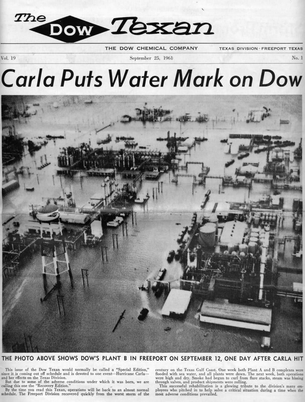
Hurricane Alicia of August 1983 was the costliest tropical cyclone in the Atlantic since Hurricane Agnes in 1972. Alicia was the third depression, the first tropical storm, and the only major hurricane of the 1983 Atlantic hurricane season. It struck Galveston and Houston, Texas directly, causing $2.6 billion (1983 USD; US$6.16 billion 2015) in damage and killing 21 people; this made it the worst Texas hurricane sinceHurricane Carla in 1961.[1] In addition, Alicia was the first billion-dollar tropical cyclone in Texas history.[2] Hurricane Alicia was the first hurricane to hit the United States mainland since Hurricane Allen in August 1980. The time between the two storms totaled three years and eight days (1,103 days).[3] Hurricane Alicia became the last major hurricane (Category 3 or higher) to strike Texas until the stronger Hurricane Bret in 1999 made landfall. Alicia was the first storm for which the National Hurricane Center issued landfall probabilities.[4] Hurricane Alicia was notable for the delayed post storm evacuation of Galveston Island (since the eye of the storm traveled the evacuation route up Interstate 45 from Galveston to Houston). The hurricane was also notable for the shattering of many windows in downtown Houston by loose gravel from the roofs of new skyscrapers and by other debris, prompting changes to rooftop construction codes. 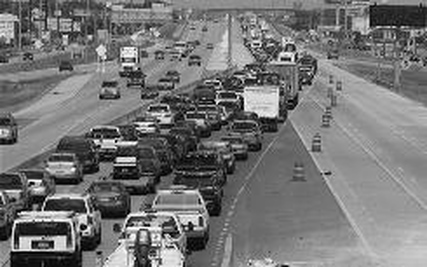
HURRICANE IKE: Brazoria County has endured numerous Hurricanes, including the storm of 1900 that destroyed Angleton’s High School and the University of South Texas. However, the Hurricane of 1909 destroyed the rebuilt schools. Hurricane Ike made landfall with Category 2 winds and Category 4 water surges. As the eye of the storm moved over Galveston Island and up Galveston Bay, Brazoria County sustained nearly 8 hours of 75 to 110 mile per hour winds. Debris was a major problem following the storm; the cost of debris removal for Brazoria County was $23,656,025.57 |
